Thursday, November 29, 2007

Dark Side-Top 5 Reasons Virginia Will Drive You Crazy


Virginia is home to roughly one fourth of the entire Appalachian Trail.
That’s a lot. And almost all thru-hikers stuggle to keep their sanity at
some point during this stretch falling victim to what has been dubbed
‘the Virginia Blues’ or simply ‘the Virginias’.


1-Newton’s Law of Bipolar Disorder. It’s impossible to stay excited
and motivated forever, particularly on the days there’s not much to
look at . What goes up must come down. I did everything I could to
try and prevent ‘the Virginias’ and I still came perilously close to
coming unglued.

2-Mileage Mania. This is where most thru-hikers start taking a look
at their overall mileage and decide that now is the time to start picking
up the pace. It’s not a bad idea but it comes at a price. High mileage
days will take it out of you and it’s still important to get your rest and
enjoy the experience.

3-Nothing to show for it. Up until now you had something dramatic to
say every two or three weeks. Now you’re still working like crazy
without nearly as much to show for it. Your pictures are OK but not
great. Reaching the top of a ridge doesn’t guarantee anything and
you can’t tell your friends back home that you’ve made it anywhere
new and dazzling.

4-Location Location Location. A lot of it has to do with where you
are in the hike and where Virginia is in the hike. The novelty has worn
off and people feel confident enough to call themselves thru-hikers. The
bad news is that there’s a lot more miles in Virginia than you’ve done
so far and Harpers Ferry isn’t even half way to Katahdin. There is still
a long, long way to go.

5-Disappointment. Now that you’re further along, minor mishaps start
to add up. One major highlight obscured by bad weather is now two or
three. The annoyances you were willing to dismiss in Carolina are starting
to get under your skin and the AT is not the ultimate experience you had
hoped for or expected. Everyone has their weaknesses and sooner or
later the trail will find yours.

Tuesday, November 27, 2007

Dark Side-Top 5 Reasons for Moral Collapse

The high ideals people started out with deteriorate
steadily the closer they get to Washington DC

1-Boredom. Looking at trees might have seemed real exciting in
Georgia. It’s not that exciting now. All the endless ups and downs.
Just give me some pizza, dancing bears, anything.

2-"I Deserve it". Who knows whether you do or not but it sounds
good. To be fair, it is quite an accomplishment to get this far and
rewarding yourself is a good thing but so is humility.

3-Because it’s there. Although it really doesn’t start in earnest
until Shenandoah, more and more services will find their way
closer and closer to the trail. Krispy Kreme in Atkins, pizza
delivery available at Partnership Shelter and so on.

4-Comfort Level. By this time your feeling pretty OK about
being on the trail and have satisfied yourself that you are
sufficiently in touch with nature.

5-Motivation. When confronted with the enormity of the
AT in general and Virginia in particular, it’s tempting to put the
miles ahead of why you’re doing them. You DO need to get there
and Virginia is a great place to pick it up but don’t lose sight
of why you came here.

Dark Side-Top 5 Reasons Thru-Hikers Don’t Get Along


1-The Great Assumption. For whatever reason, any time any
two hikers spend two nights in a row in the same place, one of
them assumes ‘we’re hiking together’. No one ever asks. And
that makes is even harder when the less interested party wants to
go their own way either on the trail or when they get into town.

2-Solitude/Reassurance. Everyone is going to need different
amounts of both as the hike progresses. And each will have a
big impact on how you act toward and respond to other hikers.
Sometimes you really need the company of other hikers and
sometimes you really don’t and it can be hard to know the
difference.

3-Partnership Issues. People will hike at their own pace, deal
with the trail in their own way and sometimes just need some
time alone. Fine. When people NEED to hike together for safety
and security, particularly women, these things can be very
problematic.

4-It worked at home. The way we speak and act toward others
is often the result of many years of trail and error. Most hikers
are pretty easygoing when it comes to manners to begin with and
don’t always realize that it may take time for people to get used
to them.

5-Points of view. From its very founding, the Appalachian Trail
was about bringing people together from different parts of the
country. The good news is that it did. The bad news is that
very often it puts you face to face with someone who has very
strong and deeply felt opinions that may be very different from
yours and the folks back home.

Monday, November 26, 2007

Highlights-Top 5 Ridgetop Views in Virginia

The best parts of the Virginia AT are the long stretches of
ridgeline meadows and in-and-out views along ridges and
among peaks.


1-Highlands. Roughly definied as the mountain group just north
of Damascus, there is nothing else like it on the AT. More than
a strip or ridge or summit, this is where everything is up high.
The mountains that make up the highlands form a high plateau
with wide open areas especially from Thomas Knob Shelter to
Grayson Highlands State Park. And don’t forget to bring an
apple for the ponies.

2-Cold Mt.
After a difficult climb, a lovely view of Mt Pleasant
and the entire Priest group is laid out before you with a lovely
ridgetop meadow to enjoy it from. Depending on whether or not
you count Calf Mt, it’s the last bald for the northbound hiker.

3-James River Face. After the disappointment of Apple
Orchard and the floating orb of death on its summit, this is just
what the view-hungry thru-hiker needs. Weaving in and out of
several different summits along a relatively smooth path before finally
wending your way down to the James River.

4-Garden Mt. This one caught me completely off guard during
my thru-hike. What a wonderful surprise to find myself on a bald
ridgetop to be capped off with a stunning view of Burke’s Garden
from Chestnut Knob Shelter.

5-Peters Mt. This one also took me by surprise also although I
found it harder to enjoy since the honeymoon phase for Virginia
was starting to end. Nonetheless there are some lovely high
meadows straddling the Virginia/West Virginia border with good
views into West Virginia.

Honorable Mention-Pearis Mt.

Sunday, November 25, 2007

Highlights-Top 5 Viewpoints in Virginia

1-Buzzard Rock. Good place to take one last longing look at
the mountains of eastern Tennessee and western Carolina. Sign
of things to come in the highlands.

2-McAfee Knob. Pretty cliche, I know, but it’s true. The view
across the valley to North Mountain with other long ridges in the
background is a classic to say nothing of the drama of the
overhanging ledge itself.

3-Tinker Cliffs. Almost the same as McAfee with a twist; a
look back at the uniquely shaped Catawba Mt which starts low
and gradually works its way up to McAfee.

4-Wind Rock.
As good a look back to Peters Mt and the
ridges beyond as you’re going to get. There’s a certain
loneliness to it given the remoteness of the valley below and
the sense of how long Virginia is turning out to be.

5-Mary’s Rock.
It’s a dramatic place to look from even if
there isn’t a lot to look at. This striking rock pinnacle towers
over the Shenandoah Valley below.

Saturday, November 24, 2007

Highlights-Top 5 Things to Know About VA Ridges


1-No Summits. When a mountain stretches 50-100 miles at roughly
the same altitude, the whole idea of a summit is irrelevant. That’s the
contour of the land in Southwest Virginia with very few exceptions.
The mountains are basically long ridges with some higher points (knobs)
and some lower points (gaps).

2-Over and Back. The southern half of the AT in Virginia consists of
crossing a group of ridges to get over to the West Virginia border and
then crossing a group of ridges to get back to the Blue Ridge. Sort of
like shoveling a pile of dirt only to have to shovel it back again.

3-Some do, some don’t. Over the course of the 250 or so miles from
Damascus to Daleville, you’ll get a little of everything. Straight up and
over. Crossing through a gap. Crossing through a high point. Following
the ridge for a short distance or following it for days.

4-How high are we? Since most of the ridges are tree covered it won’t
feel much different from walking ‘down on the ground’ particularly on the
longer ridgewalks after Pearisburg.

5-Hello Bessie. In between these long ridges are equally long valleys
with lush green pasture land. Most of these valleys are occupied by
cattle farms giving you the opportunity to practice your bovine
behavioral/communication skills.

Friday, November 23, 2007

Highlights-Top 5 Side Trails Worth the Effort


1-Spy Rock. A great view in the shadow of Maintop Mt, a fun hands-
and-feet climb to get to the top and a lovely grassy flat leading up to it.
This is a fun feature in a really great section.

2-Mt Rogers summit. OK, so there’s no view and the surrounding
highlands have views up the wazoo. There’s something special about
this spot where the altitude makes it feel more like Maine than Virginia.

3-The Priest.
You have to get a little creative on this one since there
isn’t an official side trail. When you reach the summit plateau (north of
the shelter) look for the scratch trails to the west and that will take you
to the view.

4-Dragons Tooth. I know. Calling this a side trail is a bit of stretch
since it’s clearly the reason for slugging your way up Cove Mt. Still,
it’s not on the trail and it’s a pretty challenging climb (at least to those
of us who are more hiker than climber).

5-Bear’s Den.
Even if you don’t plan on spending the night, it’s
a great place to stop for lunch or a snack. It’s a beautiful old building
with a nice view of the valley to the east.

Thursday, November 22, 2007

Highlights-Top 5 Shelters

Top 5 Shelters (Worth Screwing Up Your Mileage For)


1-Thomas Knob Shelter. Arguably the best shelter on the entire AT.
This two story gem is located with a commanding view at the head of
large meadow just below the summit of Mt Rogers. Good water, good
privy, good times.

2-Chestnut Knob Shelter. The water source on the ridge is iffy at best
so plan ahead. The view into Burkes Garden is worth it. I spent the
night in pretty crappy, windy conditions and I was still blown away
by the view.

3-Campbell Shelter.
It’s not so much the shelter as the proximity
to McAfee Knob that makes this worth shooting for. The view from
the Knob goes from good to great at sunrise or sunset and you’re a
comfortable day’s hike from Daleville.

4-Cow Camp Gap Shelter. Like Campbell Shelter the main selling
point here is that you’re so close to Cold Mt and can do it early in the
day. The downside is that it’s reached by a long side-trail which can
seem even longer if it’s been a high mileage day.

5-Rice Field Shelter. Because it’s so close to Pearisburg and hikers
have high mileage on the brain, it’s easy to bypass this one. But for the
next 60 miles views are going to be hard to come and this is one of the
best in this section sitting in an open meadow on top of Peters Mt with
a great view into West Virginia.

Wednesday, November 21, 2007

Top 5 Things to Know About the Blue Ridge Parkway


1-You're not stuck with it. It might feel that way at first since
this is the first time AT hikers have had to share the ridge (and
not just a summit) with the road. However, after Bearwallow
Gap there is relatively little contact with it. A cluster of three
crossings near Apple Orchard and one crossing below the
Punchbowl for the next 112 miles to Rockfish Gap.

2-Some of Virginia's finest. With the lone exception of the
highlands, this section of trail is as good as any in VA. Both sides
of the James River are exceptional as are Cold Mt and both sides
of the Tye.

3-Original AT route. Because the Blue Ridge Parkway follows
the original AT route and because BRP is less constrained about
opening up viewpoints, walking the Parkway has its rewards.
The downside is that roadwalking gets really old really fast.

4-Not out of the woods.
Did YOU see any ice cream places listed?
Well, you didn't and there aren't any. That doesn't happen until
Shenandoah and you need to plan accordingly.

5-It's not the downward spiral (yet). Hikers are often conflicted
about the encroachments of civilization. Most welcome, the
opportunity to travel a bit lighter thanks to a few near-the-trail eating
spots while decrying the lack of dramatic scenery. Fear not. Moral
collapse is just around the corner but you're not there yet.

Tuesday, November 20, 2007

Top 5 Most Overlooked Views in Virginia


1-Three Ridges.
Due to a combination of exhaustion, the decision
whether or not to take the Mau-Har trail and being overshadowed
by the Priest group this one tends to be just an 'oh yeah' for thru-hikers.

2-Tarjacket Ridge.
Another good passing view in the shadow of
the much more dramatic one from Cold Mt.

3-Cedar Cliff. By this point, northbounders are so obsessed with
getting to Waynesboro that even a lovely morning view into the
Shenandoah Valley doesn't impress.

4-Bluff Mt.
Not to be confused with the North Carolina Bluff Mt.,
the outlooks from this mountain are a nice continuation of the James
River Face.

5-Brushy Mt (north of I-77).
I know. Most of Brushy is a huge
bore, slogging on it for days on the final push to Pearisburg.
But there's a succession of views into the valley that are pretty
neat.

Monday, November 19, 2007

The 5 Things I Remember About Shenandoah


1-Back from the brink. This was where I struggled with 'the
Virginias' the most and very nearly came unglued. It was only when
I read an entry in a shelter log that said "No rain, no pain, no insane,
no Maine" that I started to feel better.

2-Wildlife. Because the animals in the park have been protected
longer here than most other places on the AT, you are much more
likely to see them. The only bear I saw on my thru-hike was in
Shenandoah.

3-Milkshakes. Now the fun starts. I didn't resupply in Shenandoah
that much. I just had a lot of milkshakes.

4-Calf Mt.
I'm sure there are some other OK views in the park.
And I probably didn't maximize my knowledge of the park by
hiking at night. But that's all I remember from my thru-hike.

5-The Kissing Tree.
Right in front of Pass Mt are two trees with
disease-growths that look like...well...you get the idea. I was
joined that evening by two hikers who most likely wanted to do
the same.

Sunday, November 18, 2007

Top 5 Camping Spots on the Virginia AT

1-Wind Rock. Maybe it's a bit chancy given the number of day
hikers but some places are worth it especially such a prime spot for
sunsets.

2-Hog Camp Gap.
A beautiful meadow just north of Cold Mt. And
the only campsite on the AT with a swing.

3-James River.
The view of the James with the morning mist
coming off the water is one of those truly magical moments on
the AT.

4-Dragon's Tooth.
Spread the pain of Cove Mt out over two days
and catch a good morning view. Nice flat sandy area next to
'the tooth'.

5-Lambert's Meadow Campsite.
Not to be confused with the
shelter 0.3 miles away. I guess you have to be in the right mood
for it. It's a wooded campsite in a sloping bowl complete with a
picnic table and a babbling brook.

Saturday, November 17, 2007

The 5 Nastiest Parts of the Whole Virginia AT

1-Cove Mt. Retire the trophy. This one wins, hands down. It’s
asty going up and nasty coming down. I’ve done this going both
directions and it was painful both times.

2-Potts Mt. Approaching Wind Rock from the south there is a
rock maze the equal of anything on the AT. These rocks are
bigger and more embedded than the Pennsylvania variety but every
bit as challenging.

3-The Roller Coaster. Just when you think you’re on the home
stretch comes this test of perseverance. Relentless ups and downs
with few, if any views. And when there is a ledge, there’s nothing
to see.

4-Sinking Creek Mt.
Lots of views across to an utterly dull and
featureless ridge across the valley and rocks rocks rocks. I felt
like I couldn’t stand up straight the whole time.

5-Humpback Mt.
Rocky and uneven footing. Redeemed somewhat
by the views to the south (including a mountaintop golf course).

Honorable Mention: Mau-Har Trail. Would have been #2 if it was
part of the AT.


GOODBYE VIRGINIA...

Thursday, November 15, 2007

Side Trails

AT Side Trails in Virginia


Having thru-hiked the Appalachian Trail in 2001 and then re-hiking the Carolina Tennessee border in 2004 I was looking for a section hike with a twist. So I decided to explore as many side trails as I could in Virginia (between Waynesboro and Peters Mt) and then hike the Allegheny Trail north to Blackwater Falls State Park. This is the journal from that hike.

May 8, 2005
Humpback Rocks. I left the Inn at Afton with a sense of mission. I was determined to savor this part of the trail that had been lost to mileage-mania, thru-hiker soap opera and visions of all-you-can-eat pancakes at Weasie’s Kitchen during my thru-hike. Seize the day, smell the flowers, all that good stuff. Glass Hollow overlook was certainly a nice enough place, a good snack spot reasonably close to the trail but Humpback Rocks tested my new outlook. It was a steep 0.3 miles down to the rocks and rather awkward to manage with a backpack. There’s a good view but unless you’re brimming with energy, it’s probably best to leave it for the throngs of day-hikers who make the trip up from the Blue Ridge Parkway. As it was, my legs were not brimming with energy on the first day out and I ended up going another two miles before making camp just above the southern viewpoint of Humpback Mountain.


May 9, 2005
Mau-Har Trail. I had always heard that the Mau-Har Trail was tough but I had hoped that because I was going southbound and downhill that it wouldn’t be too bad. Sadly, it turned out to be every bit as difficult as described. The terrain was steep, the footway was very rough and there were some taxing upslopes even going southbound before it leveled off to meet the AT. It does cut off some mileage but you wind up paying for it.
Relieved to be back on the AT, I took a break to dip my feet in the Tye River before ascending the Priest. I was disappointed not to be in better shape. I struggled to make it to the Priest summit by sundown. I guess you tend to remember how your hikes ended rather than how they began.


May 10, 2005
Lovingston Spring Trail. The sign for the Lovingston Spring Trail was as clear as day right across from the side trail to the Seeley-Woodworth Shelter. And having missed the trail to Little Priest in the morning, it was certainly a welcome sight. Things had gone fairly well up to that point. I got a nice early morning view from one of the outlooks just off the trail on The Priest and had a nice chat with another hiker on Spy Rock.
The afternoon however, turned out to be a big fat headache. The Lovingston Trail was well blazed at the beginning, faintly blazed after a hard left turn and not blazed at all after the Trail to Yankee Horse Ridge. I managed to find my way to the summit of Rocky Mt but never did find the trail to the viewpoint amid all the communications gear. On top of all that, it was hot, the visibility was poor and I was pretty grumpy by the time I got back to the AT by way of Forest Service roads. Not even the open ridewalk on Cold Mt cheered me up. It was too hazy. I sheltered at Cow Camp Gap with a father and son from Florida.


May 11, 2005
No side trails today although I have day-hiked Pleasant Mt which is outstanding with sweeping views from Apple Orchard Mt to The Priest. Today was almost totally viewless except for a glimpse or two of the Lynchburg Reservoir since the AT has been relocated around Peddlar Dam . There were a couple showers before the long ascent to the Punchbowl. When I finally got to the Shelter there was an earnest group of students from Antioch College in Indiana and rather scornful Californian unimpressed with the mountains in the east. The Punchbowl was a complete cacophony of critters for most of the night but when it finally quieted down I was almost sure I heard footsteps...is that you Little Ottie?!

May 12, 2005
Little Rocky Row Trail. After the Lovingston Spring debacle it was good to have a nice surprise. There were good views from the summit of Bluff Mt as well as on the traverse around Silas Knob. And although the Little Rocky Row Trail is viewless with few blazes it was easy to follow and the woods walk along the ridge was a quiet, lightly travelled, unhurried trail with a magical quality to it. It was the kind of trail I was hoping for when I set out on my side-trail mission. I hitched a ride into Glasgow and spent the night.


May 13, 2005
Balcony Falls Trail. This is another one of those ‘I don’t know if I’d substitute it for the AT but it was fun to try’ trails. Once I persuaded the shuttle driver to take me there and figured out which set of blazes to follow (don’t follow the blue diamonds), things went fine. The farther up you go, the better it gets with a nice long view of Gunter Ridge which runs parallel to the Balcony Falls Trail separated by Hellgate Creek. There’s something industrial and hellish about this area despite it being protected as part of the James River Face Wilderness.
It was overcast and cooler today with excellent visibility and after rejoining the AT the trail through the James River Face was beautiful. It’s one of my favorite parts of the trail in Virginia weaving in and out of all the different mountains. I ended up at the Thunder Hill Shelter which I had all to myself. I celebrated by building a fire and burning a small hole in my shorts.


May 14, 2005
Flat Top Mountain. Native Americans believed that some mountains were not meant to be ascended. I don’t know how they felt about this one but in my case Flat Top seems to be one of those mountains that’s given me nothing but trouble. On a previous visit, I got all tangled up in the Peaks of Otter road system and never found the trailhead. On this trip, I heard sirens wailing for half an hour before I reached the northern trailhead and learned that someone had broken their ankle on the summit and needed to be rescued. I scored a free bottle of water from one of the rescue crews and headed up the mountain. The summit was shrouded in fog and the footing was so treacherous I could easily see how someone could break an ankle and felt lucky not to break my own. The thick cover of leaves made it difficult to judge what was already an uneven and rocky stretch of trail. I made it up and over and headed down to the Peaks of Otter Lodge. As I settled in for the roadwalk back to the AT along the Blue Ridge Parkway someone offered me a ride. I have to admit I felt kind of guilty. Although I’m not a purist I felt like I was getting off way too easy. I got back on the AT at Bearwallow Gap and hurried on to Bobblett’s Gap Shelter.


May 15, 2005
Daleville, Daleville, Daleville. What I had been so eager to criticize at the beginning of the trip is what I have now become, just another hiker with nothing but the comforts of town on the brain. No side trails. No grand thoughts. No stopping to smell the roses. Just a straight shot to the Best Western Hotel and a day of rest, restaraunts and resupply.

May 17, 2005
Andy Layne Trail/North Mountain Trail. After a very pleasant ascent to Scorched Earth Gap, it was a pretty steep descent on the Andy Layne trail to Catawba Creek. However, the creek and valley around it are exceptionally beautiful and a nice tribute to a beloved member of the Roanoke ATC. The North Mountain Trail starts across the road from the Andy Layne trailhead. It is lightly maintained but not hard to follow. However once I got up to the ridgecrest it was a series of endless ups and downs that just went on and on and on. When I finally came to a sign that said ‘water’ I didn’t even care that there wasn’t a
trail to the water source. I was happy just to get a break from the viewless monotony. Camping on the ridge was the only consolation since you can’t do that on the section of the AT that runs parallel.


May 18, 2005
North Mountain Trail (part duh). What was I thinking?! Either I was hoping to bypass one of the many ups and downs or I thought I was farther along the trail than I was but I took the first right turn that showed and paid the price. Better signage might have helped but I really have no one to blame but myself. Instead of bypassing another viewless summit I wound up descending via the Turkey Trail (how appropriate). I ended up going southeast on a Forest Service road for what seemed like forever before reascending North Mountain via the Deer Trail and then following the North Mt trail to Route 311. And as if that weren’t enough, I got to spend the afternoon beating my brains out on Cove Mt
before making camp half a mile above Trout Creek. If I wasn’t in shape before, I’m
definitely getting into shape now.


May 19, 2005
No side trails today. I had enough to deal with just going over Sinking Creek Mt and its long awkward traverses along the ridge. Thankfully the rainshowers hit before I was on the ridge and then again in the evening after I had pitched my new tarp tent

May 20, 2005
If I’d been a little more organized, I could have checked out the Potts Mountain Trail but at this point I’m looking ahead to the Allegheny Trail. Mostly I was glad that my tarp tent held up well during a night of heavy rain. Sinking Creek Valley was beautiful in the early morning mist and Wind Rock was the other highlight of the day. I was able to dry some of my gear during lunch at the War Spur Shelter and I had Bailey Gap Shelter to myself for the night.


Wednesday, November 14, 2007

Allegheny Trail

May 21, 2005

Bailey Gap Shelter (AT) to Hanging Rock
Raptor Migration Observatory (18.1m)

My first day on the Allegheny Trail turned out to be a sign of things to come. Kind of like a one day version of the ten days that followed; hope giving way to disappointment and frustration with something unexpected and positive in the end.

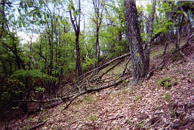
The weather was pleasant and I was looking forward to a change of pace. The bridge over Stony Creek was out so there was a bit of a road walk in the morning. I had lunch at the Pine Swamp Branch Shelter and reached the Allegheny Trail around 2:00pm. Right away I found myself in a tangle of blowdowns and it was no small relief to come out onto a dirt track. After a few miles though, I grew bored with the track and found myself wishing for an honest to goodness off-road trail. Be careful what you wish for.

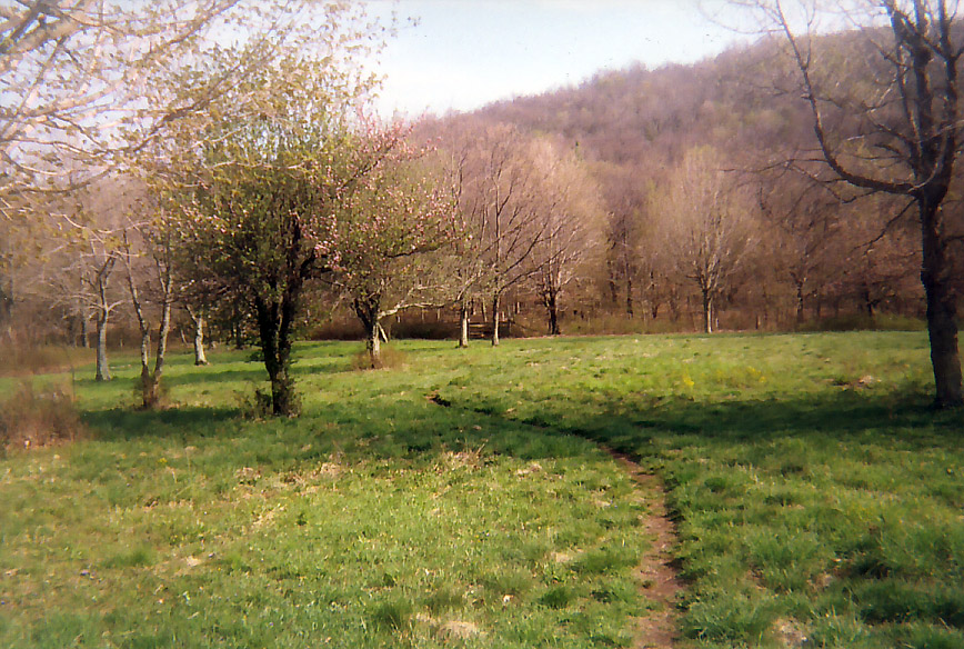
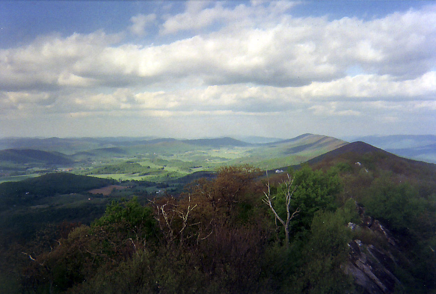
Soon enough the trail left the track and there was no discernible treadway at all. It was a long hard tangled mess. Even more disheartening was looking up at the homes and mowed fields along the top of the ridgeline while having to slug it out down below. I had hoped to camp in a ridgetop meadow by Neel’s Rocks but since there were no views from either I pressed on. Afer another mile I came to the side trail to the Hanging Rock Raptor Migration Observatory.

The title was such a mouthful I hadn’t given it any thought. It turned out to be a viewing tower with a commanding view of the whole area. What’s more, it was open and unmanned. What a bit of luck! I got to watch the sun set and rise over the long ridges of Virginia and West Virginia. Apparently it is used in the fall to get a count of raptors and other migrating hawks who use the updrafts from the mountains on their long journey south. It was to be by far the best view of the trip.


May 22, 2005

Hanging Rock to Allegheny Mt (10.8m)

The Allegheny is not yet one continuous trail. The southern 21 miles are separated from the rest of the trail by about 20 miles. I had arranged a ride with Outdoor Adventures in Neola but I was not specific enough about where to meet. My ride went to where the trail ended. I went another 2.8 miles to what the guidebook considered the end of the section in Laurel Branch. After about 2 1/2 hours we figured out what had happened, found each other and went to White Sulphur Springs for supplies and a bite to eat before resuming the hike at the Jerry’s Run Trailhead. In spite of the missed connection, it was nice to have that transportation item done with. Now I could focus on the trail.

May 23, 2005

Allegheny Mt to Meadow Creek Mt (21.2m)

The relief of being on the main part of the trail soon gave way to disappointment and discouragement at the faint blazing and vague treadway. Threatening weather did not help as it obscured what should have been a nice view from the mountaintop meadow of Smith Knob. On Meadow Creek Mt blowdowns were everywhere. Progress was slow in some places and I considered myself lucky to find a camping spot down off the ridgeline as the thunder rumbled in the distance.


May 24, 2005

Meadow Creek Mt to Watoga State Park (18.2m)

Since I had pretty low expectations for both the trail and the weather, today was actually fairly enjoyable even if a bit soggy. The trail did improve as it skirted the Lake Sherwood trail system. After descending to Route 92 it was up to Ridgetop Rd atop Middle Mt. It rained off and on all day making it difficult to find a good spot to eat lunch when it wasn’t raining. All day I thought about camping in Watoga State Park and eating in the restaraunt only to change my mind at the last minute and camp out on the trail.


May 25, 2005

Watoga State Park to Marlin Mt Shelter (18.0m)

No rain but chilly today. A steep descent from Pyle Mt with an equally steep ascent of Buckley Mt with a few intermittent views through the trees along the Buckley ridgetop. I actually met another human being for the first time since getting on the main section of the trail, a man walking his two dogs. Sure enough, it meant I was getting closer to town which in this case was Huntersville WV.

Being on the trail for a few days has a way of making towns and stores look bigger than they otherwise would. The convenience store at the edge of town seemed HUGE. I
flirted with the idea of staying at the B&B but since it was only 2:30 and not raining I pressed on to the Marlin Mt shelter.


May 26, 2005

Marlin Mt Shelter to Cass Inn (20.8m)

File under ‘things that make you go hmm’ when the view from the power line crossing is better than the view from a summit fire tower. Of course after missing a turn off of the jeep road the trail was in pretty rough shape and I was saying things other than hmm. Down Marlin Mt and up Thorny Creek Mt and into Seneca State Forest. Thorny Creek Mt was a pretty strenuous affair with lots of ups and downs. I ate lunch in one of the picnic shelters before heading to the fire tower. In its time, it must have had quite a view. Unfortunately the trees around it have completely overtaken the tower and there is no view whatsoever except for the trees.

The road walk over Thomas Mt was fairly pleasant and except for a cluster of blowdowns approaching Sitlington I made pretty good time. I took a wrong turn when I got to the rail trail and although very beautiful I saw more of the Greenbrier River than I should have before finally arriving in Cass.

Cass, WV is an interesting town. Most of the old railroad buildings have been taken over by the state and are part of the scenic railroad. I arrived on the eve of the first run of the year and all of the state park housing was full. My alternative was to stay at the Cass Inn which turned out to be much more entertaining. The owner is a very colorful emergency room nurse with a pet deer named Baby. It must be pointed out here that some names are only properly spoken by southerners and Baby is certainly one. Once I got checked in and cleaned up we had a nice ‘set’ on the porch before I excused myself to get my TV viewing needs met and retire.


May 27, 2005

Cass Inn to Sandy Ridge Saddle (14.8m)

Pulling out of town after a fun overnight is hard enough. (We had a nice morning chat over coffee on the front porch). Getting smacked around by the horribly misnamed Little Mt made it a very long day. Staying on the trail was especially challenging in several places where the blazes were faint or mysteriously changed color. Sidehills around summits were the most vulnerable to blowdowns. Late in the day the trail improved to a nice grassy road on the descent of Little Mt. I decided to experiment and camp on the moss at the high point of Sandy Ridge.


May 28, 2005

Sandy Ridge Saddle to John’s Camp Shelter (15.4m)

Sleeping on moss...not such a good idea especially after a rainy spell. If it didn’t hold water as much it wouldn’t be moss. The trail maintenance was noticeably better heading into Durbin. It was the town that turned out to be in tough shape. About half of the buildings in town are shuttered and many of them looked about ready to fall down. The only place that I could find serving breakfast was a store-front church holding a community breakfast/fund raiser.
Although most of the people serving the meal were older there was a drum set with
guitars and amps ready to go. Apparently this church likes to deliver the Gospel at a high volume. I did not wait to have my soul improved at the cost of my hearing and was in and out of town in about 45 minutes. Just in time to get rained on (was God trying to tell me something?!)
I took the alternate route to avoid the unbridged crossing of the North Fork of the
Greenbrier River. This meant a two mile road walk and then descending to rejoin the
trail. The rain stopped after about an hour or so and the trail improved markedly as I approached the edge of the Gaudineer Scenic Area on Shavers Mt. In retrospect I should have made the side trip to the tower but I was holding out hope for the 0.5 miles of ‘spectacular’ views promised by the guidebook further along the trail. As it was I cheered myself up by building a fire at John’s Camp Shelter.


May 29, 2005

John’s Camp Shelter to Birbun Run Campsite (22.3m)

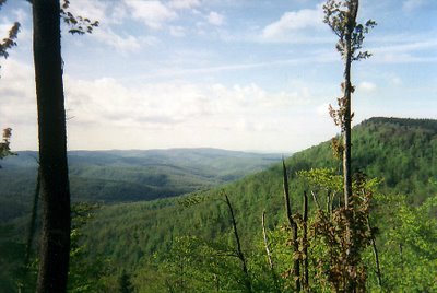
Yet again Charlie Brown has the football yanked away before he can kick it, the Great Pumpkin fails to show and the 0.5 miles of spectacular open scenery turns out to be a dud. No 360’ view. Just a rather ordinary look across to another long non-descript mountain. To be fair, it did go on for a while and although it wasn’t completely open, it was more view than I had seen since Hanging Rock but it was still a disappointment.

On the positive side, I made good miles thanks in part to a long stretch of rail trail leading to the town of Glady. The trail condition and blazing improved greatly from the upper junction with the High Falls of Cheat Trail (prior to the rail trail) which is a lovely wooded camping spot. It improved even more north of Glady where the trail was being used as part of an adventure race over Memorial Day week-end. At first I ran into a group of half a dozen mini-vans at the trailhead with people looking well supplied but not going anywhere. Then I started running into groups of two and three spandex clad hikers with racing numbers on them. Eventually after passing enough teams I found out what was going on. And despite following a very demanding course and not having slept for two days, the competitors seemed to be in remarkably good shape and good spirits. I felt like a slacker hiking only 22 miles and camping at Birbun Run.


May 30, 2005

Birbun Run Campsite to Low Bridge Campsite (19.4m)

This was nothing more than a long river-walk. Make that a very long river-walk. Watching the weather deteriorate (again) and working my way around a trail wash-out were the only excitement and neither turned out to be a problem.

But then another thing happened. As I made camp that evening, I realized that in spite of all my frustration with the condition of the trail and the lack of views, now that the end is in sight I think I’m going to miss it. There’s something about exploring new places and meeting new people combined with solitude and wilderness that is good for the soul. It may not be perfect but it’s still worth doing.


May 31, 2005

Low Bridge Campsite to Blackwater Falls State Park (8.6m Est)

I’ve met so few people on this trail that except for the occasional late start there hasn’t been much opportunity for anything unexpected to happen...until today. It was beautiful and sunny. And I was settling in to my road walk along the Dry Fork River when a voice came out of a house inviting me in for a cup of coffee. I wasn’t in any hurry so I took him up on it. We chatted for a while and then he offered me a ride in the back of a dumptruck which was on its way to take him to work. At the very least I figured it would make a good story.

I really had no idea what to expect. When it finally showed up it turned out to be
immaculately clean. We went up and away from the river, up one small mountain road
after another until we were out in the open in high mountain fields with outstanding
views. It was more scenic than anything I had seen since Hanging Rock. They dropped
me off at a store about a mile or so south of the Blackwater Falls State Park trail system.
After lunch I reconnected with the Allegheny Trail which was a rather gravelly bike trail at that point and hiked down to the junction with the American Discovery Trail. From there I went to the Blackwater Falls Lodge for the night.

June 1, 2005

Planes, Trains and Automobiles (final comments) I didn’t bother with the northernmost 90 miles since it was all roadwalking of one sort or another. But if I had it to do over again, I wouldn’t do it like this. Transportation from Blackwater Falls turned out to be a huge headache both for me and for the outfitter who agreed to give me a ride.

The nearest bus stop was an hour away in Morgantown. When we managed to find the
bus stop we learned that it had moved to a new location that day. That took half an hour to find since no one knew where it was and only a few people seemed to know about the old bus stop. I missed my bus and wound up taking a later one. A better choice would have been to hook up with the American Discovery Trail and get closer to public transit that way.